Ie Island [伊江島]
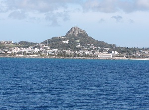
Ie Island and Tatchu (Mt.Gusuku)
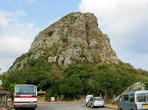
Tatchu (Mt.Gusuku)
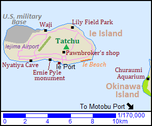
Ie Island ("Iejima" in Japanese) is located about 6 km northwest of Churaumi Aquarium and Ocean Expo Park on Motobu Peninsula.
The island is about 8 km from east to west and 2.5 to 3.5 km from north to south in width.
The land is flat as a whole, but there is only Mount Gusuku ("Gusukuyama" in Japanese,城山) about 172 meters high in the easten part of the island.
It is the landmark of Ie Island, and the nickname is "Tatchû" meaning "mountain with pointed peak" in Okinawa language.
It is geologically rare in the world, because it was formed by slipping new bedrock under old bedrock then pushing the old bedrock up.
The visitors can climb to the top on foot.
There is Ie Port on the south coast, and there is the main town around the port.
The port and town are located just to the south of Mount Gusuku.
The ferry is operated from Motobu Peninsula.
In the island, there are some natural spots and the traces of Pacific War (World War II).
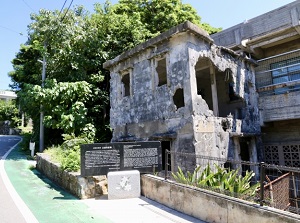
Ruin of public pawnbroker's shop
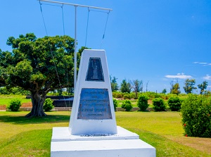
Ernie Pyle Monument
There is Ruin of public pawnbroker's shop (公益質屋跡) in the northern part of the town and near the foot of Mount Gusuku.
The building was built in 1929, but it was destroyed by U.S. Military in the Battle of Okinawa in 1945.
It is the only building retaining the original form in this island.
In addition, about 3,500 people in Ie Island were killed in the battle.
And there is Ernie Pyle Monument in the west part of the town.
Ernie Pyle (Real name is Ernest Taylor Pyle, 1900-1945) was a famous American journalist and had accompanied U.S. Military in the Battle of Okinawa.
But, he was killed by a sniper of Japanese army in Ie Island on April 18.
He was buried in the cemetery in Hawaii and this monument was built in this island.
Every year, the memorial service is held on Sunday around April 18.
Iejima Airport is at the center of the island, but it has no regular flight now.
And there is an air station of U.S. military base at the northwest part of the island.
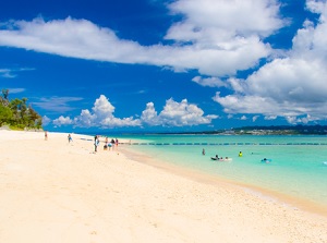
Ie Beach
Lily Field Park
Ie Beach is the beautiful beach on the southeastern coast of the island and is to the east of Ie Port.
The beach is covered with white sand, and the length is about 1 km.
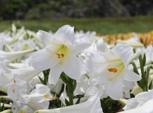
There is Lily Field Park near the northeast coast.
A million Easter lilies are planted, and Lily Festival is held in late April every year.
View from the observatory of Waji
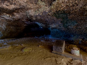
Nyatiya Cave in Ie Island
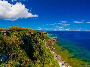
There is Waji (湧出) about 2 km west of Lily Field Park.
It is the steep cliffs along the north coast.
The cliffs are over 60 meters high, and we can see the beautiful sea below our eyes.
"Waji" means "spring" in Okinawa language.
Clear water is springing from the cliff and it has been used the daily life water.
Nyatiya Cave is located by the sea about 3.5 km west of Ie Port.
In the cave, there is "Chikara-ishi" stone.
If infertile woman lifts the stone, it is said that she will have a baby.
During the Battle of Okinawa, this cave was used as an air-raid shelter.
How to get here
By express route bus, about 2 hours from Naha terminal to Nago terminal.
Then, by route bus, 37 minutes from Nago terminal to Motobuko (Motobu Port).
By ferry, about 30 minutes from Motobu Port to Ie Port.