Mount Fuji [富士山]
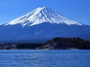
Mt.Fuji from Lake Kawaguchi
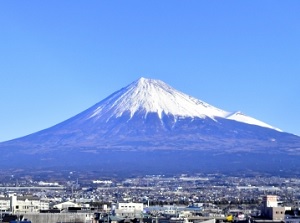
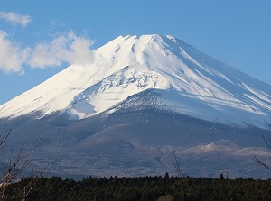
Mt.Fuji from Fuji city
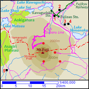
1) Fuji-Q Highland 2) Arakurayama Sengen Park
3) Shinobi-no-Sato 4) Oshino-hakkai
5) Shiraito Falls
Red circles are the 5th stations and are the entrances of mountain trail.
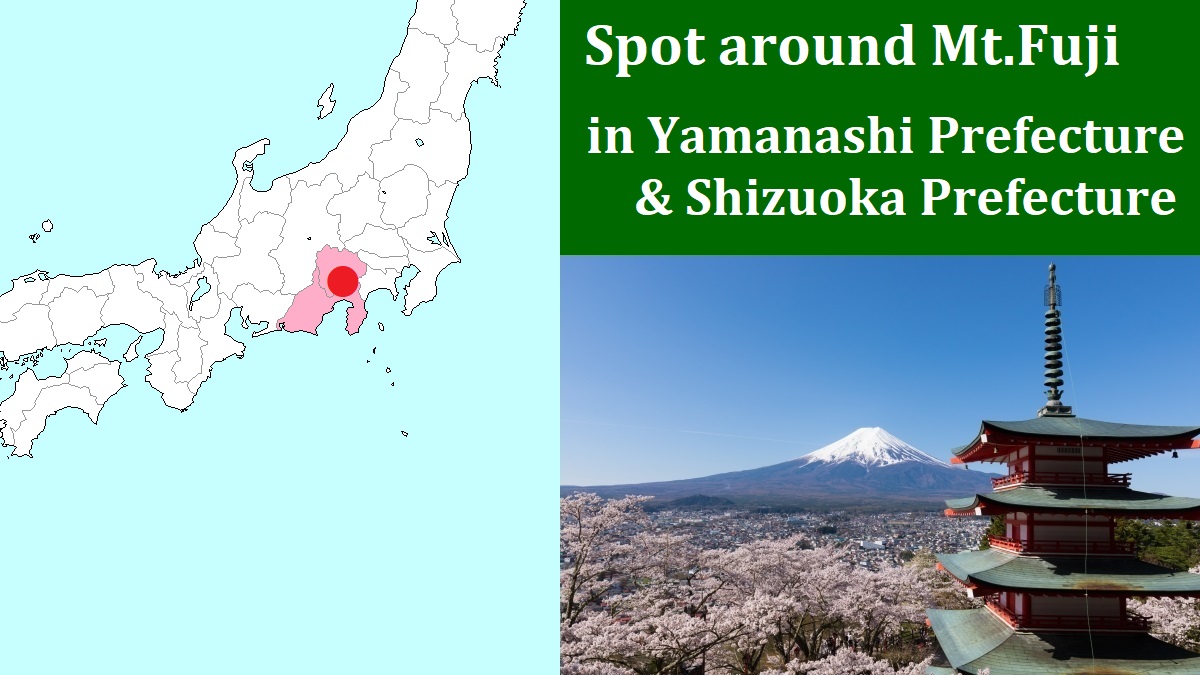
Mount Fuji is an active volcano on the border between Yamanashi and Shizuoka Prefectures.
It is located about 100 km west-southwest of Tokyo.
The altitude is 3,776 meters, and is the most highest mountain in Japan.
In Japanese, it is called Fujisan.
It is almost perfectly conical, and there are few mountains screening its view around it.
So we can view the beautiful sight from various places.
Of course, we can see at the foot of the mountain and its surrounding areas.
And, we can view at Lake Ashi in Hakone and at some observatories in high buildings in Tokyo and Yokohama.
Additionally, the seat in the train of Tokaido Shinkansen is also one of the good view spots.
When you have gotten on the Shinkansen train "Nozomi", you can catch the view of Mount Fuji on your right about 40 to 50 minutes after leaving from Tokyo station. (Between Mishima and Shin-Fuji stations)
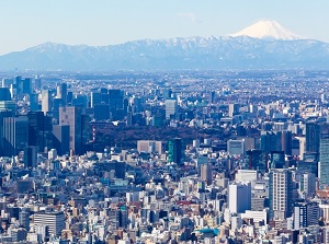
Mt.Fuji from Tokyo
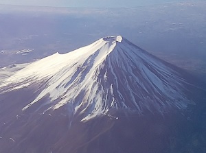
Mt.Fuji from airplane
The season that we can see Mount Fuji clearly is around winter (usually from November to March).
Because, it is fine on most days and the air is clean.
In addition, the scenery that snow covers the top of Mt.Fuji is beautiful.
That is seen from November to May.
In the other seasons, it is often veiled in a haze or hidden by clouds.
For Japanese people, Mount Fuji has been the symbol of the Japanese scenery and the object of worship since ancient times.
The words of "Fuji" are found in the oldest Japanese poetry books "Man-yoshu" compiled in the 8th century.
And the artists in the 19th century have left many Ukiyoe (woodblock prints) with Mount Fuji.
Because Mount Fuji has not only the beautiful scenery but also above cultures, it was designated as a World Cultural Heritage site with surrounding some lakes, shrines and spots in 2013.
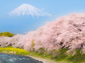
Mount Fuji & cherry blossoms
Crater formed in 1707 on the southeast slope
Mount Fuji is an active volcano.
There is a huge crater 780 m in diameter and 237 m deep on the top of the mountain.
From the 8th to the 11th century, it had been very active and had often erupted.
The subsequent great eruptions occured in 1511 and 1707.
Especially, the eruption in 1707 was very great.
In the year, the greatest earthquake in Japanese history struck the whole area along the south coast of Japan.
Large tsunami hit the coast soon and many towns were destroyed.
Only 49 days later, great eruption of Mt.Fuji occured suddenly.
A large deal of volcanic ashes shot up into the air and fell even in Edo city (current Tokyo) about 100 km from Mt.Fuji.
It is thought that there is some sort of relationship between the eruption and the earthquake.
Another large crater formed by the eruption remains on the southeast slope.
Since that, Mount Fuji has been tranquil for over 300 years.
But it is surely an active volcano.
Japanese government and relative local governments have created the disaster prevention plan for the eruption of Mt.Fuji.
Mount Fuji cannot be tranquil and safe forever.
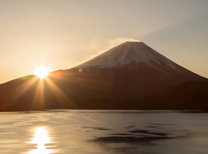
Sunrise at Lake Motosu
Mt.Fuji in summer around Lake Yamanaka
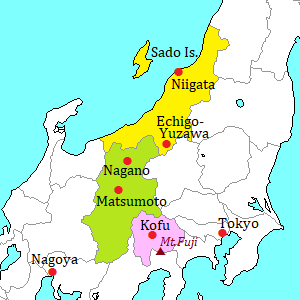
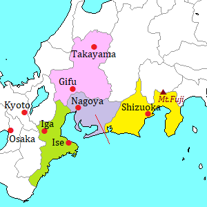
By the way, there are some sightseeing spots at the foot of Mount Fuji.
Especially, five lakes are dotted on the north foot and a resort zone is formed.
Mount Fuji climbing
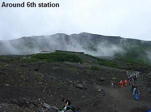
There is no ropeway and cable car to the top of Mount Fuji.
If you want to go to the top, you must walk and climb on the steep slope without trees.
It is reckless to climb on impulse while you travel around Mt.Fuji.
It takes a whole day for the climbing.
Many climbers underestimate the nature of Mt.Fuji.
On the top, average temperature is around 5 degree C and it is often windy.
And, there is a sudden change of the weather sometimes.
You should be dressed for trekking and take precautions against the cold.
It's very dangerous to climb Mt.Fuji wearing a light outfit.
Some climbers suffer hypothermia.
And some climbers get altitude sickness.
The beginners of climbing must take care of everything.
Because the slope is the field of only soils and rocks, even rockfall occurs sometimes.
In August in 2019, a climbing Russian woman was killed in the accident of rockfall near the top.
Every year, more than 200,000 people climb Mount Fuji.
Especially. foreign climbers are increasing recently.
But, some climbers have bad manners for mountain climbing.
Some climbers throw away trash.
Some climbers set up a tent on the climbing path.
Some climbers have a barbecue near lodge.
It is said that Mount Fuji becomes dirty.
Please be a good and clever climber.
General visitors can climb to the top of Mount Fuji only in July and August.
From 2025, the following rules apply to the visitors at the 5th station.
- Climbing fee is 4,000 yen, and the climber pays it at the entrance gate.
- Only 4,000 climbers can climb in a day from Yoshida gate (Kawaguchiko side).
- The gate is closed from 14:00 to 3:00 of the next day.
- The climber with unsuitable clothes and insufficient equipment for climbing cannot enter the gate.
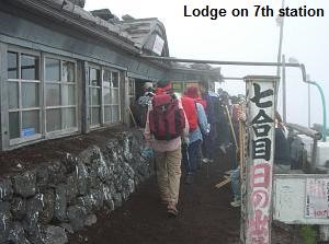
The lodges on the mountain are also open only in the period.
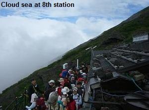
On the weekends and holidays in the period, particularly, big crowds of people arise around the top, regardless of day or night.
There are the following four starting points to climb.
All of them are on the 5th stations of the mountain, and you can go there by bus or car.
But there is no hotel around each point.
You must start from any town at the foot of Mount Fuji.
Please check the following site before climbing.
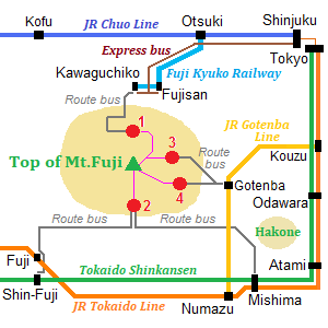
1) Kawaguchiko side 5th station
2) Fujinomiya side 5th station
3) Subashiri side 5th station
4) Gotenba side 5th station
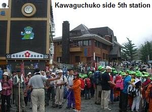
Kawaguchiko side 5th station (North side)
The most popular starting point. (The altitude : 2,305 m)
From Lake Kawaguchi, a highway Fuji Subaru Line about 30 km long is set up.
Many general tourists also visit here.
So, there are several rest houses, a post office and a foreign money exchange.
Of course, there is a large parking lot, but here is crowded with many cars and buses during the peak season.
To the top, 7.5 km. About 6 hours.
Lodges along the route : 19
Fujinomiya side 5th station (South side)
The second popular starting point. (The altitude : 2,400 m)
There are a shop and a restaurant.
Here is a large parking lot, but here is also crowded with many cars and buses.
To the top, 5 km. About 5.5 hours.
Lodges along the route : 9
From Subashiri side 5th station (East side)
Relatively uncrowded starting point. (The altitude : 2,000 m)
This route merges into Kawaguchuko route at the 8th station.
To the top, 7.8 km. About 6 hours.
Lodges along the route : 13
Gotenba side 5th station (Southeast side)
Very uncrowded starting point. (The altitude : 1,440 m)
The starting point is the lowest, so it is a hard route.
To the top, 11.0 km. About 8 hours.
Lodges along the route : 7
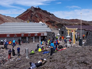
Top of Mt.Fuji
Photo by Fujinomiya City
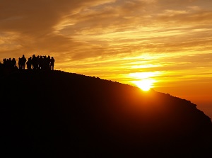
Sunrise on the top of Mt.Fuji
Photo by Fujinomiya City
How to get here
To Lake Kawaguchi
By express bus, about 2 hours from Shinjuku station.
Or, by limited express of JR Chuo Line, from Shinjuku to Otsuki, about 1 hour and 10 minutes.
Then, by Fuji Kyuko (Fujikyu) railway, from Otsuki to Kawaguchuko, about 43 minutes by limited express, about 55 minutes by local train.
To Kawaguchiko side 5th station
By route bus, about 50 minutes from Lake Kawaguchi.
It is operated from spring to autumn.
To Fujinomiya side 5th station
Get off at Mishima or Shin-Fuji station of Tokaido Shinkansen.
From Mishima station, by route bus, about 2 hours and 5 minutes.
From Shin-Fuji station, by route bus, about 2 hours and 15 minutes.
These are operated only in July and August.
To Subashiri side 5th station
Get off at Gotenba station of JR Gotenba Line.
From Gotenba station to 5th station, by route bus, about 1 hour.
These are operated only from July to early September.
To Gotenba side 5th station
Get off at Gotenba station of JR Gotenba Line.
From Gotenba station to 5th station, by route bus, about 40 minutes.
These are operated only from July to early September.