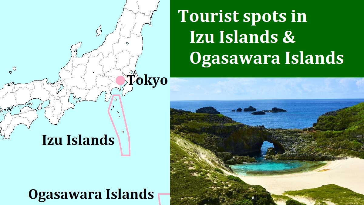
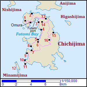
Chichijima [父島]
Chichijima is the main island in Ogasawara Islands.
It is located about 1,000 km south of Tokyo.
Ogasawara Islands have three groups of islands formally.
Chichijima is in the middle group named Chichijima Group (or, Chichijima Islands).
(Other groups are Hahajima Group located about 50 km south, and Mukojima Group located about 50 to 70 km north.)
Chichijima Islands have main three islands and some other small islands.
But people live only in Chichijima.
By the way, "Chichijima" means "Father island".
Like Galapagos Islands, Ogasawara Islands have never connected to any continent.
Therefore, there are many peculiar plants and birds in the islands.
The whole islands are designated as a national park.
And they were registered as a World Natural Heritage Site in 2011.
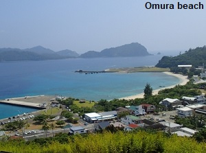
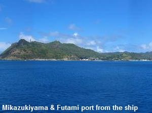
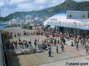
There is Futami Port in Futami Bay in the northwestern part of Chichijima, and the ship from Tokyo come in.
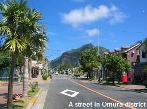
Ômura district, the only village of Chichijima, is to the west of the port.
The main sightseeing spots in this island are several beautiful beaches and the nature.
And we can meet the whales and dolphins in the sea.
We can enjoy various marine sports in this island.
Ogasawara Islands has no airport.
So we must visit here only by ship. It takes 24 hours from Tokyo.
Village-operated bus is the only public transportation in this island.
As the method of touring, there are taxi, rental car, rental motorcycle and rental bicycle.
Around Futami Bay
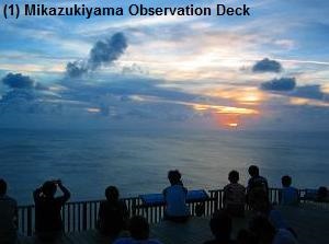
- (1) Mikazukiyama Observation Deck (三日月山展望台)
Mikazukiyma (174 m) is a mountain located about 1.5 km west of Omura district.
Because a facility of Japan Meteorological Agency was there, it is also called Weather Station Observatory.This place is popular for the expansive scenery of sunset.
The route bus go to the foot of the mountain.
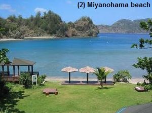
- (2) Miyanohama beach (宮之浜)
Miyanohama is a beach facing Anijima island and is located about 1.5 km north of Omura.
It is a beautiful beach, and is a nice place to dive.
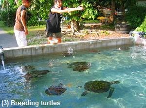
- (3) Ogasawara Marine Center (小笠原海洋センター)
Ogasawara Marine Center is a laboratory about green turtle and humpback whale.
It is located to the southeast of Futami port, and is about 2 km from Omura district.
There is a museum about turtle and the history of Ogasawara Islands.
And there is a breeding facility of green turtles.
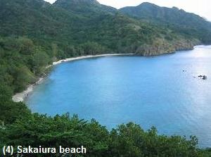
You can see hundreds of babies of green turtle. - (4) Sakaiura beach (境浦海岸)
Sakaiura beach is a calm beach and a good diving spot.
It is located about 3.5 km from Omura district.In 1944 during the World War II, a cargo ship "Hinkômaru" of Japanese army was stranded after hitting of a torpedo of U.S. in this Bay.
The ruin of the ship is at dozens of meters from the beach, so you can enjoy the exploration with a snorkel.
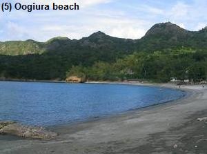
- (5) Ôgiura beach (扇浦海岸)
Ôgiura beach is a calm beach at the southeast part of Futami Bay.
It is located about 6 km from Omura district.One of a few sand beaches where you can go swimming in bare feet.
It is near the bus stop, so it is convenient to visit.
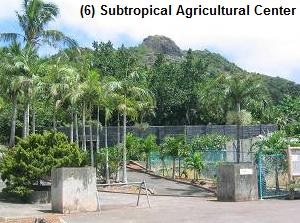
About 8 minutes from Omura district by route bus. - (6) Ogasawara Subtropical Agricultural Center (小笠原亜熱帯農業センター)
Ogasawara Subtropical Agricultural Center is an institution for development of subtropical agriculture.
It is located about 0.5 km south of Ogiura beach.We can visit its botanical garden with endemic species in Ogasawara Island.
And there is a palm garden and an observatory where we can see Futami Bay.About 3 minutes from Ogiura beach by route bus.
Southwest part in Chichijima
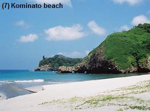
- (7) Kominato beach (小港海岸)
Kominato beach is a white sand beach located about 2.5 km southwest of Ogiura beach.
Deep forest surrounds the beach, and you visit this wide beach through the forest.
Because the bottom in the sea is white sand, it is easy to swim.
About 11 minutes from Ogiura beach by route bus.
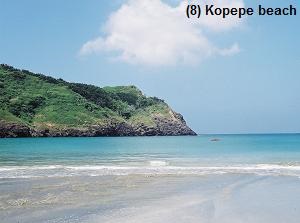
The bus stop is the terminal of route bus operation. - (8) Kopepe beach (コペペ海岸)
Kopepe beach is a coral beach.
It is located about 2 km north-northwest of Kominato beach.The beach is known as the spawning ground of green turtle.
There are coral reefs, so here is a nice place to dive.
To visit here, walk on the trail from Kominato beach.
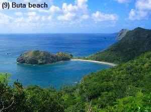
- (9) Buta beach (ブタ海岸)
Buta beach is a beach located about 1.2 km southwest of Kominato beach.
"Buta" means "pig", and pig farming had ever been carried on around here.There are coral reefs and many whitetip reef sharks come here in spring.
Because the waves are a little high, the diving is not suitable.
To visit here, walk on a mountain trail from Kominato beach.
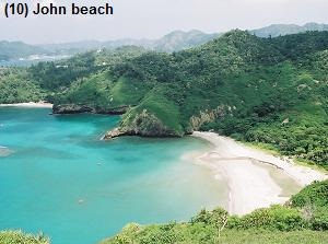
On the way, you can enjoy the good view at Nakayama Pass. - (10) John beach (ジョンビーチ)
John beach is a white beach of limestone, and it is said that this beach is the most beautiful in Chichijima.
But it is hard to visit here.
You must walk on a mountain trail from Kominato beach for 3.5 km.
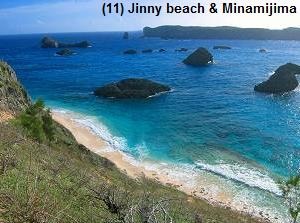
- (11) Jinny beach (ジニービーチ)
Jinny beach is also a beautiful beach.
It is located about 0.4 km south of John beach, but there is no trail.
To visit here, you must use a boat or a sea kayak by yourself.
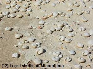
A sea kayak club in the island organizes a tour to the beach. - (12) Minamijima island (南島)
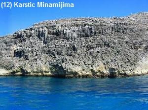
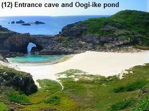
Minamijima is a small island about 1 km off from John beach.
It is a rare karstic island.
It has marine caves and Oogi-ike pond connecting to the sea.Many fossil shells remains on the beach.
Only 100 visitors can land here for natural protection.
And you must land with authorized guide and stay on the island only for 2 hours.
(So, it is convenient to join a field tour.)
East part in Chichijima
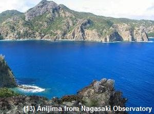
- (13) Nagasaki Observatory (長崎展望台)
Nagasaki Observatory is an observatory at the north part of the island.
It is located on a mountain about 2.5 km east of Omura district.From the observatory, we can see Anijima island about 0.8 km away from Chichijima.
You will find the flowing tide in the strait ("Anijima-seto" in Japanese).Because the route bus is not operated, rental car is a method to visit.
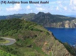
- (14) Mount Asahi (旭山)
Mount Asahi is a mountain 267 meters high.
It is located only 1 km east of Futami port.There is an observatory is on the top.
We can see Futami port and Anijima island.The mountain is near Futami port, but the walking trail (about 0.7 km) to the top is set up from the east side.
The road to the entrance of the walking trail is about 5 km from Omura district.
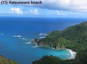
- (15) Hatsuneura beach (初寝浦海岸)
Hatsuneura beach is a small sand beach on the east coast.
The sand in this beach includes a little green sand.There is an observatory on the hill near the 8 km point from Omura district.
To the beach, you must walk on the steep slope.
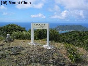
- (16) Mount Chuo (中央山)
Mount Chuo is a mountain 319 meters high, and it is the highest in Chichijima.
In Japanese, it is called "Chûôzan".There is an observatory is on the top, and it has a 360-degree view. The road to the entrance of the walking trail is about 10 km from Omura district.
How to get here
By ferry, about 24 hours. (Takeshiba 11:00 - Futami 11:00 on the next day)