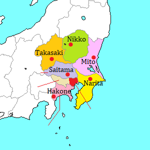
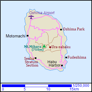
Izu-Ôshima [伊豆大島]
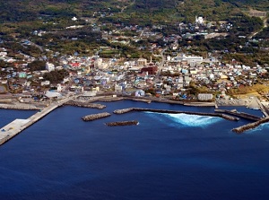
Motomachi town in Izu-Oshima
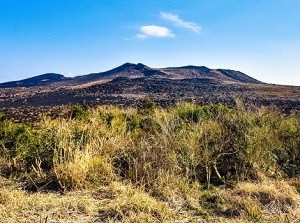
Mount Mihara
1) Mt.Mihara 2) Senba Stratum Section
3) Habu Harbor 4) Fudeshima 5) Oshima Park
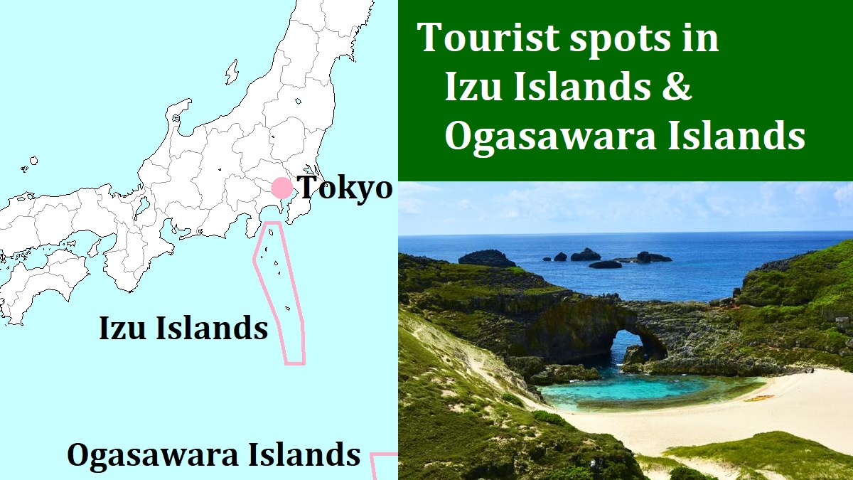
Izu-Ôshima is the largest island in Izu Islands.
("O" in the word is pronounced long in Japanese.)
It is located about 100 km south of Tokyo and about 40 km east of Shimoda city in Izu Peninsula.
The island is nearly oval like a lemon, and it is 9 km from east to west and 15 km from north to south.
The whole island is the top part of an undersea volcano.
And there is the crater in the center of the island.
It is Mount Mihara volcano.
Therefore, there are few flat lands in this island.
People have lived in this island since about 8,000 years ago.
So there are many prehistoric sites.
From the 8th to the 18th centuries, here had been a penal colony.
After that, here has been the island of fishery industry, stock raising, and sightseeing.
The main town is Motomachi (元町) located on the west coast.
There is a port and the passenger ship from mainland comes in here.
And there is Oshima Airport about 3.5 km north of Motomachi.
Camellia ("Tsubaki" in Japanese) is a symbol of Izu-Ôshima.
There are some camellia gardens in the island.
The camellias are at their best from late February to late March, and Tsubaki Festival is held in the season every year.
From Motomachi to main places in the island, several route buses run.
The buses go to all placed within 40 minutes.
And you can use taxi, rental car, retal motorcycle or rental bicycle to tour around the island.
Mount Mihara (三原山)
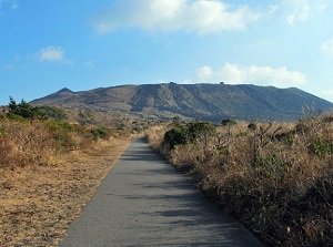
Trail of Mount Mihara
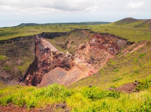
Crater of Mount Mihara
Mount Mihara ("Miharayama" in Japanese) is the active volcane forming this island.
The altitude is 758 meters.
Since ancient times, this mountain has been called "Gojinka".
It means "fire of god".
The people in this island think that the eruption of Mount Mihara is the wrath of the god.
The crater is a little south of the center of the island.
The current crater was formed by the great eruption in 1777.
In the 20th century, it erupted three times.
Particularly, when the last great eruption was occured in 1986, all people evacuated out of the island for a month.
The diameter of the rim of the main crater is about 3 km, and there are many other volcanic vents around the crater.
Since 1996, it has been allowed to approach around the creater.
Some mountain trails from the foot are set up.
(Of course, if eruptive activity starts, these are closed.)
Most popular route is from the northwest foot, and the route bus is operated to the entrance of the trail.
The visitors climb the altitude difference of about 200 meters walking for 2 km.
They can walk the full circumference of the rim of the crater.
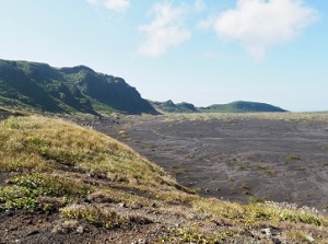
Ura-sabaku
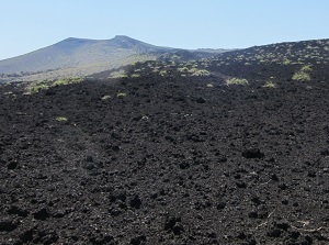
Black lava of Ura-sabaku
And wide black lava field occupies on the eastern slope of the mountain.
It is called Ura-sabaku.
"Sabaku" means "desert", and this is only certified desert in Japan.
To visit there, the visitors walk for 4 km from Miharayama Onsen stop of route bus.
Senba Stratum Section (千波地層断面)
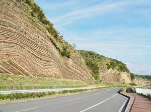
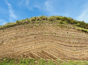
Senba Stratum Section ("Senba chisou danmen" in Japanese) is the wall showing clear stripe of stratum.
It is located in Senba district about 6 km south of Motomachi town.
This was unveiled when a road was constructed.
This wall continues for about 1 km along the road.
It is said that more than 90 layers had been formed by repeated eruptions for 1.5 million years.
It looks like "Baumkuchen" (one of German cakes).
Habu Harbor
Fudeshima
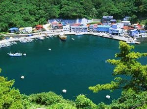
Habu Harbor (波浮港)
Habu Harbor is a small harbor at the southern end of the island.
Originally, it was a round creater lake.
It had been destroyed the edge and connected to the sea by the great tsunami caused by the earthquake in 1703.
In 1800, here was improved as a harbor.
In early 20th century, this harbor had been busy as a base of deep-sea fishing.
And, this place was the stage of some movies and novels.
It is still used as the harbor, but there is little to remind us of its past prosperity.
There are some buildings of the time around here.
On the western hill of the harbor, there is an observatory to see this historic harbor.
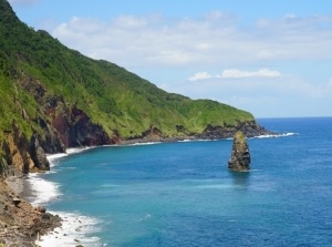
Fudeshima rock (筆島)
Fudeshima is a tall rock standing in the sea, and is located about 2 km north of Habu Harbor.
The height is about 30 meters.
Originally, it was "a volcano".
And, it is said that only the vent of the volcano remained after the all other parts had been eroded.
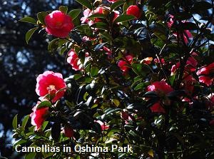
Oshima Park (大島公園)
It is a municipal park, and is located at the northeast part of the island.
It has a popular camellia garden about 7 hectares wide.
There are about 9,000 camellia trees in this garden.
The camellias are in full blossom from January to March.
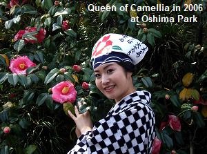
During Tsubaki Festival, this park is the main venue.
You may meet "Queen of Camellia" who has selected in the year and wears traditional Kimono "Anko" in Izu-Ôshima.
How to get here
By Airplane, about 35 minutes from Haneda airport.
By high-speed ship, from Takeshiba pier (near Hamamatsucho in Tokyo), about 2 hours by high-speed ship.
By ferry, about 8 hours. (Takeshiba 22:00 - Oshima 6:00)
From Atami, about 45 minutes by high-speed ship.