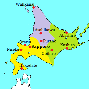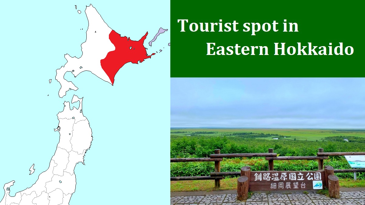
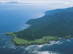
Shiretoko Peninsula [知床半島]
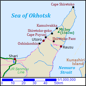
Shiretoko Peninsula is a long peninsula extending about 70 km toward northeast like a horn.
The tip of the peninsula is Cape Shiretoko.
Whole peninsula is mountainous, and there are several volcanoes as much as 1,500 meters high.
Therefore, some hot springs are dotted.
Most parts in the peninsula are covered with primary forests and wild animals and birds live in the forest.
So the northeastern half of peninsula was designated national park in 1964, and was registered as a World Natural Heritage Site in 2005.
Generally, Shari (斜里) is the gateway town to Shiretoko Peninsula.
It is on Sea of Okhotsk side of the peninsula and is located about 35 km west-southwest of Abashiri city.
There are two small villages in the middle of the peninsula.
Utoro (ウトロ) is on the northwest side of the peninsula and Rausu (羅臼) is on the southeast side.
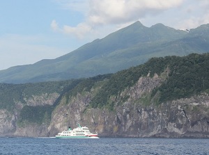
From Utoro, sightseeing ship is operated.
It sails along the north coast of the peninsula.
It takes 3 hours and 45 minutes to visit Cape Shiretoko (知床岬), and it takes 1 hour and 30 minutes to visit around Mount Iou (硫黄山).
Mount Iou is at between Utoro and Cape Shiretoko.
The sailing to Mount Iou is operated from late April to late October, and the sailing to Cape Shiretoko is operated from June to September.
Around Utoro
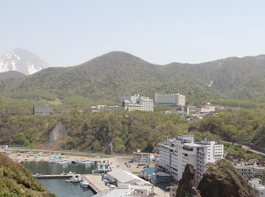
Utoro village
Photo by Shiretoko Shari-cho Tourist Association
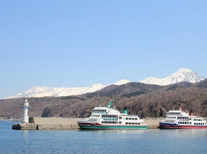
Utoro port
Photo by Shiretoko Shari-cho Tourist Association
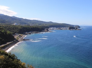
Utoro is the only village on Sea of Okhotsk side of Shiretoko Peninsula and is located about 35 km northeast of Shari town.
It is also a hot spring resort, then there are a few hotels in the village.
And there is the port of sightseeing ship to Cape Shiretoko.
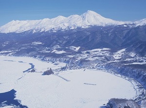
Utoro and Shiretoko mountains in winter
Photo by Shiretoko Shari-cho Tourist Association
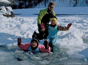
Ryuhyo walking tour
Photo by Shiretoko Shari-cho Tourist Association
In winter, ryuhyo (drift ice) comes from the north.
From late January to early March, the coast facing to Sea of Okhotsk is filled with ryuhyo.
There is no sightseeing ship for ryuhyo, but the tours to walk on ryuhyo are held at Utoro.
There are some tourist spots around Utoro.
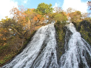
Oshinkoshin Waterfall
Photo by Shiretoko Shari-cho Tourist Association
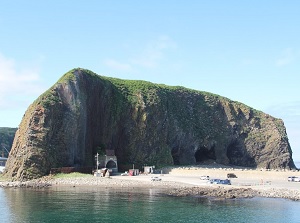
Oronko-iwa
Photo by Shiretoko Shari-cho Tourist Association
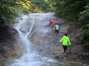
Oshinkoshin Waterfall (オシンコシンの滝)
It is a waterfall located about 6 km southwest of Utoro village, and is near the coast.
The flow split with a rock, and the water is falling down on the wall of rock swiftly.
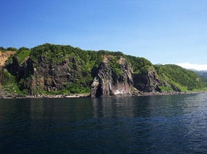
Oronko-iwa (オロンコ岩)
It is a huge rocky hill near Utoro port.
It is 60 meters high, and we can climb to the top.
We hear that the natives called "Orokko" had lived in old times, then it seemes that this rock is named after the natives.
Sunset at Yuhidai
Photo by Shiretoko Shari-cho Tourist Association
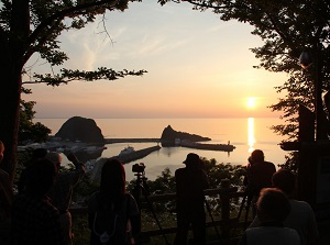
View from Cape Puyuni
Photo by Shiretoko Shari-cho Tourist Association
Yuhidai (夕陽台)
It is a nice spot for viewing the sunset, and is located in the camp site at the east end of Utoro town.
Cape Puyuni (プユニ岬)
It is a scenic overlook located 3 km northeast of Utoro.
It is at the side of the road, and we can see the Utoro town and the sunset over Sea of Okhotsk.
Real cape is located about 1 km north of this point.
Furepe Waterfall
Shiretoko-goko lakes
Photo by Shiretoko Shari-cho Tourist Association
A lake of Shiretoko-goko lakes
Photo by Shiretoko Shari-cho Tourist Association
Kamuiwakka hot waterfall
Photo by Shiretoko Shari-cho Tourist Association
Furepe Waterfall (フレペの滝)
It is located 4 km northeast of Utoro and is near real Cape Puyuni.
Groundwater falls down through the crevice on the cliff.
The volume of water is low, so it is called "Otome-no-Namida" which means "Drops of maiden tears".
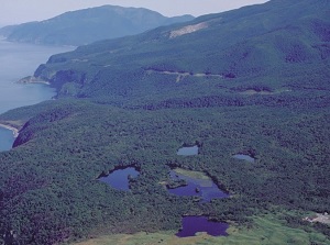
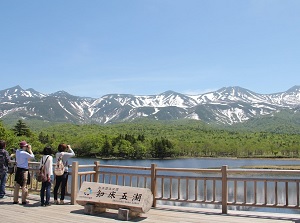
Shiretoko-goko lakes (知床五湖)
It is located 10 km northeast of Utoro.
There are five small lakes in the primary forest.
There is a walking trail passing through all lakes, and we can also select the route passing through only the First and Second lakes.
It takes about an hour to visit all lakes, and about half an hour to visit only two lakes.
We can feel a peace of the woods and may meet various wild animals.
But brown bears sometimes appear, then the trail is closed.
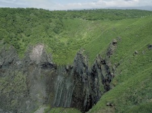
Kamuiwakka hot waterfall (カムイワッカ湯の滝)
It is a hot waterfall located 6 km northeast of Shiretoko-goko lakes.
Hot water is sprung from the hillside of Mt.Iou which is an active volcano, and runs into Kamuiwakka river.
Some tourists often bathe in this hot river.
There is Kamuiwakka waterfall (カムイワッカの滝) about 1 km downstream of Kamuiwakka hot waterfall.
The water of Kamuiwakka river falls down into the sea directly and the height is about 30 meters.
The scene is not seen from the land, but we can see it on the sightseeing ship from Shari.
The northern part of Shiretoko Peninsula
Mount Iou
Photo by Shiretoko Shari-cho Tourist Association
Cape Shiretoko
Photo by Shiretoko Shari-cho Tourist Association
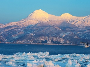
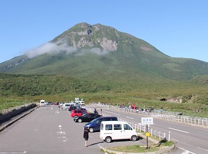
Mount Iou (硫黄山)
It is an active volcano located about 15 km northeast of Utoro village.
The height is 1,562 meters.
"Iou" means sulphur, and this volcano ejects high purity sulphur.
It is allowed to climb the mountain, but it is very hard.
Usually, the tourist views the mountain on the sightseeing ship.
Cape Shiretoko (知床岬)
It is a cape located on the tip of Shiretoko peninsula.
The land and the sea around the cape is designated as nature protected area, then general tourists cannot enter here.
There is no path to this cape.
So, we can see this cape only from sea on the sightseeing ship.
Around Rausu
Shiretoko Pass near Mt.Rausu
Photo by Shiretoko Shari-cho Tourist Association
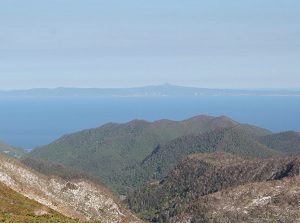
Kunashiri Island from Shiretoko Pass
Photo by Shiretoko Shari-cho Tourist Association
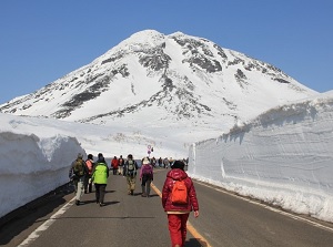
Snow wall in spring at Shiretoko Pass
Photo by Shiretoko Shari-cho Tourist Association
View from Rausu Kunashiri Observatory
Shiretoko Pass (知床峠)
It is a mountain pass on the route between Utoro and Rausu.
It is located at the level of about 740 meters.
Mount Rause (1660m), which is the highest mountain in Shiretoko peninsula, towers before us.
We can see the view of Rausu side from there.
If it is fine, we can see Kunashiri island over Nemuro Strait in the distance.
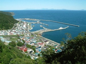
Rausu Kunashiri Observatory (羅臼国後展望塔)
It is an observatory located on the hill to the west of Rausu village.
It is at a height of 167 meters. so we can see Rausu town and Kunashiri island from there.
Kunashiri Island has been occupied by Russia since 1945, and Japan Government continues to demand the return.
The distance to Kunashiri Island is about 30 km from Rausu.
In the observatory room, there are exhibitions about the islands occupied by Russia.
How to get here
To Utoro
By local train on JR Senmou Line, go to Shiretoko-Shari station.
From Abashiri, it takes about 45 to 50 minutes.
Then by route bus, about 50 minutes from the Shiretoko-Shari to Utoro.
To Shiretoko-goko, Kamuiwakka and Rausu, route buses start from Utoro.
To Rausu
By airplane, to Nakashibetsu Airport, about 1 hour and 40 minutes from Haneda Airport (Tokyo).
By route bus, about 10 minutes from the airport to Nakashobetsu bus terminal.
Then by other route bus, about 1 hour and 30 minutes from the bus terminal to Rausu.
Between Utoro and Rausu
Route bus is operated and it takes about 50 minutes.